Flood Watch as heavy rain threatens Central Indiana overnight
Courtesy:WTHR
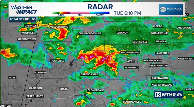
Residents across Central Indiana are being urged to stay alert as a Flood Watch remains in effect through Wednesday morning for areas along and south of Interstate 70. Forecasters warn that steady rainfall could intensify at times, with some communities seeing more than 2 inches before the system begins to weaken.
According to the National Weather Service, rain bands may repeatedly move over the same areas for several hours. That pattern increases the likelihood of localized flooding, especially in low-lying neighborhoods, urban streets and areas with poor drainage.
Officials are advising drivers to use caution overnight and into Wednesday morning. Water-covered roadways can be difficult to detect in low visibility, and even shallow flooding can pose a risk to vehicles.
Heavy rain could fall in concentrated bands
Meteorologists say the greatest concern is not just the total rainfall but how quickly it may accumulate. In the heaviest bands, totals could exceed 2 inches. When rain falls faster than the ground and drainage systems can absorb it, water can quickly pool on streets and near homes.
Creeks and smaller streams may also rise rapidly if persistent downpours develop. With soil already damp in some areas, runoff could occur more efficiently, increasing short-term flood risks.
The Flood Watch currently extends through Wednesday morning, but weather conditions will continue to be monitored in case additional advisories become necessary.
A brief lull before more storms return
After lingering showers early Wednesday, much of the region is expected to experience a cloudy but quieter stretch during the late morning and early afternoon hours. However, the break in precipitation may not last long.
Additional rainfall is forecast to develop late Wednesday afternoon and continue into the evening. Temperatures are expected to climb close to 60 degrees, creating a slightly more unstable atmosphere compared to earlier in the week.
Forecasters note that this setup could allow a few stronger storms to form, particularly south of Interstate 70.
Marginal risk for strong storms
The Storm Prediction Center has placed parts of Central Indiana under a Level 1 out of 5 marginal risk for severe weather on Wednesday. While widespread severe storms are not anticipated, isolated stronger cells could develop.
The primary threats include brief gusty winds and small hail. Heavy rainfall within these storms could also contribute to localized flooding concerns, especially in areas that receive repeated downpours.
Residents are encouraged to remain weather aware and monitor updates as conditions evolve through midweek.
Warmer temperatures ahead
Despite the unsettled pattern, temperatures are expected to trend warmer as the week continues. Wednesday’s high is forecast near 59 degrees, followed by scattered rain and storms Thursday with highs reaching the upper 60s.
By Friday, temperatures could climb into the mid-70s, although scattered showers may still be possible. The warming trend signals a shift toward more springlike conditions, even as periods of rain continue to move through the region.
Staying prepared
With multiple rounds of rainfall expected, officials recommend monitoring local forecasts and avoiding travel through flooded areas. Taking precautionary steps now can help reduce the risk of damage or dangerous situations.
As heavy rain continues to fall across Central Indiana, residents should stay alert for updated weather information and potential changes to advisories.
Source: WRTV Indianapolis
About the Author

Praise Swint
Wpseo_editor
Praise Swint is a contributor at Revelence, covering stories across news, entertainment, and culture.