Photo credit: Denver storm (X)
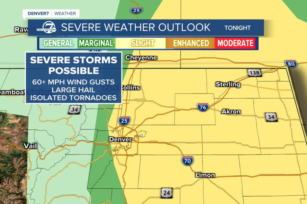
A flood watch is in effect for parts of northeastern Colorado until 10 p.m. today as another round of afternoon storms moves across the Denver metro area and the state’s Eastern Plains. Some storms are capable of producing large hail and wind gusts over 60 mph east of Interstate 25. Temperatures will stay about five degrees below normal both today and through the weekend, with highs holding in the low to mid 80s as monsoon moisture keeps the pattern active.
Which areas are under the flood watch
The watch covers Elbert, Lincoln, eastern Adams and Arapahoe, Washington, Morgan, Logan and northeastern Weld counties in the Denver area, running from 2 p.m. until 10 p.m. today. A separate flash flood watch is also in place near the Aspen Acres burn scar in the mountains. Burn scar areas lose their ability to absorb rain, which makes them especially prone to sudden flooding, even from storms that would not cause problems elsewhere.
How much rain Denver is expecting
Denver can expect roughly half an inch of rain total from today through Sunday night, spread across multiple rounds of storms rather than one continuous rain event. Today’s activity is developing in the mountains first before pushing into the Front Range between 3 and 6 p.m., with lingering showers possible into the evening as storms move onto the plains.
Does the severe weather threat continue into the weekend
Yes, and Saturday actually carries the higher risk of the two days. A slight risk for severe storms is in place Saturday in Denver, with the potential for gusty winds and large hail as storms push out onto the plains during the afternoon and evening. Sunday brings another round of showers and storms with partly cloudy skies, though confidence in severe weather is lower than Saturday. Highs both days stay in the low 80s.
When the pattern actually breaks
The unsettled pattern does not break until early next week, and even then the shift comes gradually rather than all at once. Monday brings more sunshine and minimal storm chances with highs in the mid 80s, and temperatures keep climbing from there. Tuesday reaches 90 degrees again under mainly sunny skies, the first time that has happened in several days. Wednesday and Thursday settle into a mix of sun and clouds with seasonal highs in the upper 80s, with only a slight chance of a quick shower midweek.
What residents in flood prone areas should do
Residents should avoid driving through flooded roadways regardless of how familiar the route seems, since it takes surprisingly little moving water to sweep a vehicle off the road. Anyone in or near the Aspen Acres burn scar area should have an evacuation plan ready and should pay close attention if a flash flood warning is issued rather than just a watch, since a warning means flooding is imminent or already occurring. Staying tuned to local alerts through the overnight hours matters most, since storms tracking onto the plains after dark are harder to see coming than storms during the day.
This is an active weather situation, and forecasts for storm timing, coverage and intensity can shift throughout the day. Residents should check local radar and official alerts for the most current information before making travel plans.
About the Author