Courtesy:egor-litvinov from unsplash

A powerful stretch of severe weather is sweeping across the Central United States, with tornadoes, massive hail and damaging winds already reported as part of a multi-day storm threat expected to last through the week.
The system began intensifying Monday, producing confirmed tornadoes across several states, including Kansas, Iowa, Minnesota and Wisconsin. Meteorologists warn this is only the start of repeated rounds of dangerous thunderstorms that could impact millions of residents through Friday.
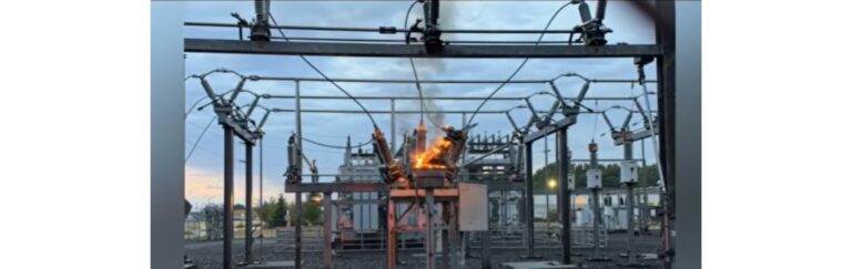
Large hail, in some cases nearing the size of softballs, has already been recorded, while strong winds have knocked down trees and power lines in multiple areas.
Tornadoes and destruction reported across states
Early damage reports highlight the severity of the storms. In parts of Kansas, entire structures were destroyed after tornadoes touched down, leaving communities scrambling to assess the aftermath.
Emergency officials confirmed that a lake community in Linn County took a direct hit, with buildings heavily damaged. In nearby areas, additional tornado activity displaced residents and forced emergency crews to arrange temporary shelter.
Farther north, severe weather extended into Minnesota and Wisconsin, where both tornadoes and large hail were reported. Meanwhile, parts of Illinois experienced strong winds that led to power outages and infrastructure damage.
Despite the destruction, only minor injuries have been reported so far, offering a small measure of relief as the system continues to evolve.
Peak day could bring the most intense storms
Meteorologists say Tuesday may be the most active day of the week, with a widespread risk zone stretching from West Texas through Oklahoma and into the Great Lakes region.
Major cities including Chicago, Milwaukee and Des Moines are under an elevated risk level, with more than 14 million people in the potential impact zone.
Storms expected to develop later in the day could produce:
Damaging hail large enough to break windows and dent vehicles
Strong winds capable of uprooting trees and cutting power
A few tornadoes, some of which could reach significant strength
As these storms move eastward into the evening, additional regions including parts of Michigan, Indiana and Ohio could also face severe conditions.
Continued threats through midweek and beyond
The severe weather pattern is expected to persist into Wednesday, though the intensity will depend on how long earlier storms linger. If clouds and rain limit daytime heating, it could slightly reduce the strength of new storms.
Even so, forecasters emphasize that hail and wind damage remain the primary concerns, with isolated tornadoes still possible.
Another surge of energy in the atmosphere is forecast to trigger a final round of storms on Friday, particularly across Oklahoma and Iowa. While details are still developing, the potential for another round of severe weather remains high.
Relief is expected by the weekend, when a shift in weather patterns should bring cooler temperatures and calmer conditions.
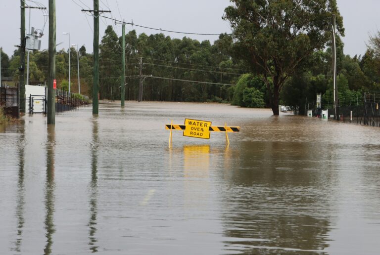
Flooding concerns grow in the Great Lakes
In addition to severe storms, flooding has emerged as a major threat, especially in parts of Wisconsin and Michigan where rivers are already swollen from recent rainfall and melting snow.
Flood watches are in effect for millions of residents, with flash flood warnings already issued in several areas. Rising water levels have led to road closures and stranded vehicles in parts of Wisconsin.
Authorities in Michigan are closely monitoring conditions near key dams, where water levels are approaching critical thresholds. Residents in vulnerable areas have been advised to prepare for possible evacuations and assemble emergency supplies.
Officials warn that river levels remain unpredictable, particularly along waterways already under stress from continuous rainfall.
A week demanding vigilance
As the Central US faces multiple days of hazardous weather, officials are urging residents to stay alert, monitor forecasts and follow safety guidance.
With tornadoes, hail, damaging winds and flooding all in play, this prolonged storm pattern serves as a reminder of how quickly conditions can escalate during severe weather season.
Source: CNN via Apple Valley News Now