Courtesy:ABC7 Chicago

A fast-moving line of severe storms swept across parts of the Midwest late at night, bringing dangerous weather conditions to communities in Chicago and surrounding areas.
The system, which stretched across northern Illinois and into Wisconsin, quickly intensified as it moved east-southeast, prompting multiple warnings and urgent alerts. Meteorologists tracking the storm warned that the conditions were rapidly evolving, with heavy rain and lightning already visible before the main line arrived in the city.
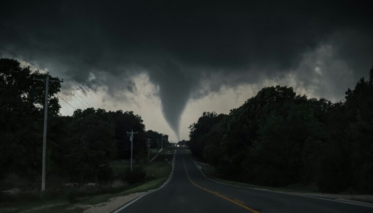
Residents in areas north of Chicago began seeing flashes of lightning and darkening skies as the storms approached, signaling the arrival of a powerful weather system that had already triggered tornado warnings across the state line earlier in the evening.
Tornado alerts raise concerns across region
One of the most serious concerns tied to the storm system was the potential for tornado activity. Earlier in the night, tornado warnings were issued in parts of Wisconsin, including areas like Kenosha and Walworth County, where sirens sounded as the storms intensified.
The presence of a tornado watch across the broader region added to the urgency, remaining in effect until midnight. Weather officials closely monitored rotation within the storm cells as they crossed into Illinois, noting that conditions were favorable for isolated tornado development.
Even in areas where tornadoes did not form, the threat alone prompted heightened awareness, with residents encouraged to stay indoors and remain alert as the storm line advanced.
Powerful winds and hail create опас conditions
As the storms pushed into northern Illinois, attention shifted to another major threat, damaging wind gusts. Meteorologists indicated that winds could reach between 50 and 60 miles per hour, strong enough to cause damage to trees, power lines and structures.
In addition to high winds, hail was detected within the storm system, with some areas potentially seeing stones up to one inch in diameter. These conditions added to the risk for anyone caught outdoors or driving during the height of the storm.
The combination of wind, hail and intense rainfall created hazardous conditions across multiple counties, including Cook, DuPage, Lake and Kane. Severe thunderstorm warnings remained in effect for these areas as the line of storms continued to move through.
Heavy rain and lightning slow travel
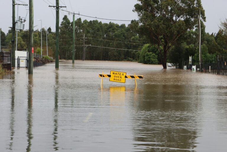
Heavy rainfall quickly became a major concern as the storms reached suburban communities. In areas such as Huntley and Woodstock, drivers encountered sheets of rain that reduced visibility and caused water to pool on roadways.
The rainfall was accompanied by nearly constant lightning, creating a dramatic but dangerous display across the night sky. Thunderstorms moved quickly, but their intensity caused disruptions even in the short time they passed through.
Despite the heavy downpours, traffic remained relatively light in some areas due to the late hour, which helped reduce the risk of major incidents on the roads. Still, officials urged caution, as conditions could change rapidly with additional storm activity expected.
Storms move rapidly toward key areas
As the system advanced, several communities found themselves directly in its path. Areas including Wheeling, Northfield and Schaumburg experienced the brunt of the storm early, while locations such as Niles, Evanston and parts of Chicago were next in line.
The storms also moved toward major landmarks and transit hubs, including O’Hare International Airport and Wrigley Field, raising concerns about delays and disruptions.
Forecast timing suggested the system would continue pushing through the region over a short window, impacting neighborhoods in quick succession as it tracked east-southeast.
More severe weather expected to follow
Even as the initial line of storms moved through, forecasters warned that the threat was far from over. Additional severe weather was expected in the following day, keeping the region on alert for continued instability.
The overnight storms served as a reminder of how quickly weather conditions can shift, especially during active periods across the Great Lakes region. With multiple hazards occurring at once, from tornado risks to damaging winds and flooding concerns, officials emphasized the importance of staying informed and prepared.
As the system gradually moved out of the immediate area, attention turned to potential flooding and the possibility of renewed storm development in the hours ahead.
Source: ABC7 Chicago